Geologic History
Updated 14 February 2014
This section provides a brief timeline of the geologic history of the main events that have shaped the south Okanagan as we can see it today. For more detail please see Cannings (2009) for a clearly written narrative description and Roed and Fulton (2011) for detailed descriptions, diagrams and maps. The most up-to-date and comprehensive map of the bedrock geology of the Okanagan Valley is Okulitch (2013). For a provincial geologic history, see Cannings and Cannings (2011) and for a focus on southern BC, see Mathews and Monger (2010).
The timeline presented below is arranged from oldest to youngest, so the most recent geologic events are at the end. A simplified geologic map of the South Okanagan is provided below.
180 to 60 million years ago (mya) (Jurassic Period)
Accretion of terranes onto the west coast of North American continent. This was the process of a number of micro-continents and island arcs being crushed into the western side of the continent. This is one of the reasons for the north-south alignment of mountain ranges in BC and the fact that the ranges features different rock types.
55 to 34 mya (Eocene Epoch)
The Eocene was a very active period in the evolution of the Okanagan landscape.
36 to 24 mya (Oligocene Epoch)
Uplift of metamorphic and plutonic rocks leads to development of Okanagan fault. The Okanagan fault resulted in westward movement of rock materials of up to 100 km. The fault is the reason for the major differences in rock types on the east (metamorphic and plutonic) versus the west side (sedimentary, volcanic, plutonic). In general the fault follows the centre of the valley south into Skaha Lake and then zigs and zags a bit through to Osoyoos. The Okanagan Valley Fault is classified as a normal fault, with the hanging wall to the west and the footwall to the east.
2.5 mya to 10 kya (Pleistocene Epoch)
During this time period there were a number of glacial and inter-glacial periods. The most recent (Fraser) glaciation occurred from 25,000 to 12,000 years ago, and is the event that we know the most about as succeeding glaciations tend to destroy evidence of earlier glaciations. Evidence of the Fraser Glaciation is clearly visible in the silt cliffs along Okanagan Lake and the sculpted bedrock landforms such as Giant's Head and the Skaha Bluffs.
References:
Cannings, R. 2009. Roadside Nature Tours Through the Okanagan: A Guide to British Columbia's Wine Country. Greystone Books. 182p.
Cannings, S, Nelson, J and Cannings, R. 2011. Geology of British Columbia: A Journey Through Time. Greystone Books. 144p.
Okulitch, AV. 2013. Geology, Okanagan Watershed, British Columbia (3 sheets). Geological Survey of Canada, Open File 6389. http://geoscan.nrcan.gc.ca/starweb/geoscan/servlet.starweb?path=geoscan/fulle.web&search1=R=292220
Mathews, W and Monger, J. 2010. Roadside Geology of Southern British Columbia. Heritage House Publishing. 404p.
Roed, MA and Fulton, RJ (eds.) 2011. Okanagan Geology South. Okanagan Geology Committee. 238p.
This section provides a brief timeline of the geologic history of the main events that have shaped the south Okanagan as we can see it today. For more detail please see Cannings (2009) for a clearly written narrative description and Roed and Fulton (2011) for detailed descriptions, diagrams and maps. The most up-to-date and comprehensive map of the bedrock geology of the Okanagan Valley is Okulitch (2013). For a provincial geologic history, see Cannings and Cannings (2011) and for a focus on southern BC, see Mathews and Monger (2010).
The timeline presented below is arranged from oldest to youngest, so the most recent geologic events are at the end. A simplified geologic map of the South Okanagan is provided below.
180 to 60 million years ago (mya) (Jurassic Period)
Accretion of terranes onto the west coast of North American continent. This was the process of a number of micro-continents and island arcs being crushed into the western side of the continent. This is one of the reasons for the north-south alignment of mountain ranges in BC and the fact that the ranges features different rock types.
55 to 34 mya (Eocene Epoch)
The Eocene was a very active period in the evolution of the Okanagan landscape.
- Granite intrusions that will eventually form the plutonic rocks of the east side of the southern Okanagan valley
- Initiation of the Okanagan fault. This fault runs the full length of the valley and continues down into Washington State. See more below.
- Volcanism in the Okanagan due to crustal relaxation and thinning. Resulted in the development of a number of local volcanic features including Giant's Head, Munson Mtn, Mt Boucherie, Knox Mt.
- Paleo river system develops that results in what we now see as the White Lake Formation sedimentary rocks at places like Sumac Ridge. This river system that flowed north.
36 to 24 mya (Oligocene Epoch)
Uplift of metamorphic and plutonic rocks leads to development of Okanagan fault. The Okanagan fault resulted in westward movement of rock materials of up to 100 km. The fault is the reason for the major differences in rock types on the east (metamorphic and plutonic) versus the west side (sedimentary, volcanic, plutonic). In general the fault follows the centre of the valley south into Skaha Lake and then zigs and zags a bit through to Osoyoos. The Okanagan Valley Fault is classified as a normal fault, with the hanging wall to the west and the footwall to the east.
2.5 mya to 10 kya (Pleistocene Epoch)
During this time period there were a number of glacial and inter-glacial periods. The most recent (Fraser) glaciation occurred from 25,000 to 12,000 years ago, and is the event that we know the most about as succeeding glaciations tend to destroy evidence of earlier glaciations. Evidence of the Fraser Glaciation is clearly visible in the silt cliffs along Okanagan Lake and the sculpted bedrock landforms such as Giant's Head and the Skaha Bluffs.
References:
Cannings, R. 2009. Roadside Nature Tours Through the Okanagan: A Guide to British Columbia's Wine Country. Greystone Books. 182p.
Cannings, S, Nelson, J and Cannings, R. 2011. Geology of British Columbia: A Journey Through Time. Greystone Books. 144p.
Okulitch, AV. 2013. Geology, Okanagan Watershed, British Columbia (3 sheets). Geological Survey of Canada, Open File 6389. http://geoscan.nrcan.gc.ca/starweb/geoscan/servlet.starweb?path=geoscan/fulle.web&search1=R=292220
Mathews, W and Monger, J. 2010. Roadside Geology of Southern British Columbia. Heritage House Publishing. 404p.
Roed, MA and Fulton, RJ (eds.) 2011. Okanagan Geology South. Okanagan Geology Committee. 238p.
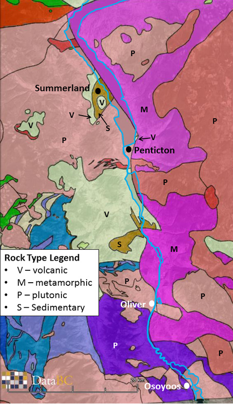
Bedrock geology of the south Okanagan area. General rock types are indicated: V - volcanic (dacite), M - metamorphic (myolenite gneiss), P - plutonic (granite, granodiorite), S - sedimentary (siltstone to conglomerate).
Blue lines are approximate outlines of lakes and Okanagan River.
Data from Government of British Columbia (Data BC) as displayed in Google Earth. For detailed bedrock geology see Okulitch (2013) listed on the resources page.
